search-icon
Underway, Making Way

The third and final leg of the Bahamas’ expedition left the dock at Nassau around 8 pm last night.  The research team was all assembled on the Golden Shadow by 5:30 pm and had a safety muster on the aft deck.  Remember, safety is no accident.  After a great dinner, the scientists prepared for the research ahead.

Jeremy Kerr (right) and Anesti Stathakopoulos (left) are preparing the ground truthing gear.


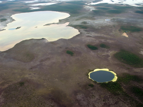
After steaming south all night we arrived at the southern tip of Andros Island.  Actually, Andros Island is an archipelago, or chain, of three different islands.  The islands are North Andros, Mangrove Cay, and South Andros.  Tidal creeks, or bights, separate the islands.  Due to the narrow separations, most people consider them one island.  Andros Island is the largest in the Bahamian archipelago.  It is 104 miles (167 km) long and at its widest is 45 miles (72 km).  The west side of Andros is known for its extensive mangroves, seagrass, and sand flats.  Andros’ interior boasts the world’s largest collection of blue holes.  Blue holes are usually circular vertical caves that can be quite deep and extensively connected.  They are the result of erosion when the islands of the Bahamas were exposed during ice ages throughout geologic history.  At some points the sea level dropped as much as 390 feet (119 m).  There are almost 200 blue holes on Andros Island.

Blue hole on Andros Island

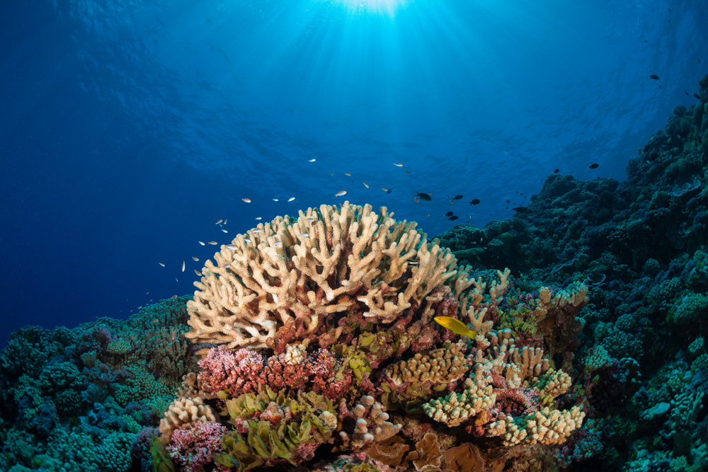
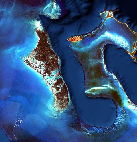
The east side of Andros is home to the world’s third largest barrier reef system.   This system runs north and south for ~142 miles (229 km) and west to east for 1-2 miles (2.5 km).  The reef system stays relatively shallow from 60 feet (18 m) or less and then the sea floor abruptly drops down to 6000 feet (1800 m) into a body of water called the Tongue of the Ocean (check out its shape below).  The Tongue of the Ocean is part of the Great Bahama Canyon.  It separates Andros Island and Providence Island.  The Tongue of the Ocean was formed about 100 million years ago.  It is the result of subsidence, when land shifts downward relative to sea level, and erosion during times of low sea levels.  Due to the mixing of water and relative proximity to the Andros Barrier Reef, the waters of the Tongue of the Ocean are ecologically important to large pelagic organisms such as billfish and whales. The word pelagic is a term used to describe organisms that live in the middle of the water column and not associated with the bottom.  Those organisms are called demersal (near the bottom) or benthic (on or in the bottom).

Andros Island and the Tongue of the Ocean


Written by Jack Seubert

(Photo/Images by: 1  Jack Seubert, 2  Dr. Sam Purkis, 3  Landsat imagery

To follow along and see more photos, please visit us on Facebook! You can also follow the expedition on our Global Reef Expedition page, where there is more information about our research and our team members.

Related Posts

World Oceans Day: Protecting the Ecosystems That Protect Us

This World Oceans Day, the global community is being challenged to think differently about the ocean.

The 2026 World Oceans Day theme, “Reimagine: Beyond the World We Know, A New Relationship With Our Ocean,” invites us to recognize that the ocean is not something distant or separate from our lives. It regulates our climate, supports our economies, provides food for billions of people, and sustains the natural systems that make life on Earth possible.

Few places illustrate this connection more clearly than the coastal ecosystems that protect our shores and support marine life. While coral reefs, mangrove forests, and seagrass meadows are often…

Read More

After the Storm: Standing with Our J.A.M.I.N. Family in Jamaica

There are moments in this work that feel heartbreakingly familiar.

Two weeks after we completed our Jamaica Awareness of Mangroves in Nature (J.A.M.I.N.) programming, Hurricane Melissa made landfall. A powerful Category 5 hurricane, Melissa is now tied with Hurricane Allen in 1980 for the strongest winds ever recorded in an Atlantic storm. Like Hurricane Dorian, which devastated The Bahamas in 2019, Melissa will be remembered as one of the strongest hurricanes on record in the region.

For 11 years, the University of the West Indies Discovery Bay Marine Laboratory and William Knibb Memorial High School have been more than program partners. They have welcomed us into their classrooms and labs, shared meals and laughter, and committed themselves to educating their students about mangroves and coastal resilience. These colleagues and students are not distant collaborators. They are family.

And they were hit hard…

Read More
Privacy Overview

This website uses cookies so that we can provide you with the best user experience possible. Cookie information is stored in your browser and performs functions such as recognising you when you return to our website and helping our team to understand which sections of the website you find most interesting and useful.  You can view our complete Privacy Policy here.

Strictly Necessary Cookies

Most of our cookies are used to improve website security and reduce spam. These cookies should be enabled at all times. They also enable us to save your preferences for cookie settings.

3rd Party Cookies

This website uses Google Analytics to collect anonymous information such as the number of visitors to the site, and the most popular pages. Keeping this cookie enabled helps us to improve our website.