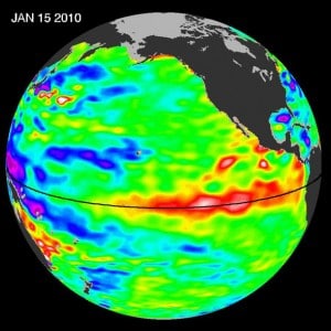
Posts Tagged ‘Weather’

El Niño in the Galapagos

Tuesday, June 12th, 2012

June 12, 2012

You can’t talk about coral in the Galapagos without talking about the atmospheric phenomenon called El Niño Southern Oscillation (ENSO). Normally, west-blowing trade winds push warm waters into the western Pacific Ocean. Every four or five years on average, though, the trade winds die down, or even reverse, and these warm waters move east as far as the west coast of South America, raising water temperatures as much as 7 to 10 degrees C.

NASA image of 2010 El Nino

NASA image of 2010 El Nino shows warm water (red areas) approaching South America

ENSO can last anywhere from nine months to two years—usually about a year and a half—but while it does, it affects weather around the world, and especially around the Galapagos. The phenomenon was called El Niño (“The Child” in Spanish) because it usually starts around Christmas. It’s considered to be linked to global warming, since it has been happening more often and with more drastic results as global temperatures have risen, but the root causes are still unclear.

Read the rest of El Niño in the Galapagos »

Under Pressure and Headed Home

Thursday, October 6th, 2011
October 6, 2011

Conducting a research expedition in the Bahamas during hurricane season (June 1 – November 30) can be a risky venture.  One never knows where or when a tropical storm (which is a low pressure system) will develop.  Depending on the size and intensity of the storm, sometimes it’s simply a matter of moving your expedition out of the way of the expected path.  Sometimes you have to steam for safe harbor and fly your researchers out of harm’s way, which was the case for the end of the Inaguas and Hogsty leg of the Bahamas Expedition (click here to read the blog “Irene and Emily:  A Tale of Two Storms”).

Deploying the RDCP in flat calm water.  Left to right:  Amanda Williams, Dr. Andrew Bruckner, CAPT Phil Renaud

Deploying the RDCP in flat calm water. Left to right: Amanda Williams, Dr. Andrew Bruckner, CAPT Phil Renaud


However, when a high pressure systems develops over a coral reef researcher’s expedition area, no one thinks of calling it off.  High pressure systems are areas of fair weather and blue skies.  Unfortunately, an area with extremely high pressure may bring some pretty intense winds.  Yesterday, a cold front began passing through the Bahamas.  Behind the front is an area of very high pressure.  The winds we experienced before the front were very calm and the sea state (wave height) was nearly flat calm.  Since the cold front, the winds have increased to more than 20 knots (22 m.p.h.) and the sea state is around 2 m (6.5 feet).  Over the next week the winds are expected to increase and become sustained at 30 knots (33 m.p.h).   By the way, tropical storm force winds begin at 34 knots.  This will increase the seas to 3 m (10 feet) or more.

Read the rest of Under Pressure and Headed Home »

GRE Website YouTUBE Channel Follow on Facebook Follow on Twitter RSS Feed Updates LOF Website

Search

Calendar

May 2013
M T W T F S S
« Apr    
 12345
6789101112
13141516171819
20212223242526
2728293031  

Archives