Posts Tagged ‘Inaguas’

Under Pressure and Headed Home

Thursday, October 6th, 2011
October 6, 2011

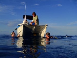
Conducting a research expedition in the Bahamas during hurricane season (June 1 – November 30) can be a risky venture.  One never knows where or when a tropical storm (which is a low pressure system) will develop.  Depending on the size and intensity of the storm, sometimes it’s simply a matter of moving your expedition out of the way of the expected path.  Sometimes you have to steam for safe harbor and fly your researchers out of harm’s way, which was the case for the end of the Inaguas and Hogsty leg of the Bahamas Expedition (click here to read the blog “Irene and Emily:  A Tale of Two Storms”).

Deploying the RDCP in flat calm water.  Left to right:  Amanda Williams, Dr. Andrew Bruckner, CAPT Phil Renaud

Deploying the RDCP in flat calm water. Left to right: Amanda Williams, Dr. Andrew Bruckner, CAPT Phil Renaud


However, when a high pressure systems develops over a coral reef researcher’s expedition area, no one thinks of calling it off.  High pressure systems are areas of fair weather and blue skies.  Unfortunately, an area with extremely high pressure may bring some pretty intense winds.  Yesterday, a cold front began passing through the Bahamas.  Behind the front is an area of very high pressure.  The winds we experienced before the front were very calm and the sea state (wave height) was nearly flat calm.  Since the cold front, the winds have increased to more than 20 knots (22 m.p.h.) and the sea state is around 2 m (6.5 feet).  Over the next week the winds are expected to increase and become sustained at 30 knots (33 m.p.h).   By the way, tropical storm force winds begin at 34 knots.  This will increase the seas to 3 m (10 feet) or more.

Read the rest of Under Pressure and Headed Home »

Emily and Irene: A Tale of Two Storms

Wednesday, August 31st, 2011

August 31, 2011

Prior to beginning our research at Little Inagua, we knew there was some “weather” occurring in the eastern Caribbean that we had to keep our eyes on.  At first, we thought we could leave one day early, transit back to Nassau, and avoid the storm.  However, when we awoke the morning of August 22nd, Captain Steve informed us that the questionable weather off to the east was blowing up into a Tropical Storm… known as Irene.

The path of Hurricane Irene

The path of Hurricane Irene

  Read the rest of Emily and Irene: A Tale of Two Storms »

Regionally Rare, Locally Abundant

Friday, August 19th, 2011

August 18, 2011 

Throughout most of the Caribbean, there are species of coral that are common and easily spotted on a dive, and those that are rare and difficult to locate.   Experienced divers can usually characterize a reef fairly quickly based on the types of corals growing there.  Some common corals that are generally easy to find include star corals (Montastrea sp.), starlet corals (Siderastrea sp.) and brain corals (Diploria sp.).  On the other hand, pillar corals (Dendrogyra cylindrus) and staghorn corals (Acropora cervicornis) are generally quite rare.  The corals of Hogsty Reef and Great Inagua have so far not followed this formula.  Living Oceans Foundation researchers have seen an unusually high number of rare corals.  Specifically, pillar corals appear to be thriving on the reefs here and staghorn corals are demonstrating remarkable resilience.  

Pillar coral (Dendrogyra cylindrus) is not a rare find around the Inaguas

Pillar coral (Dendrogyra cylindrus) is not a rare find around the Inaguas

Read the rest of Regionally Rare, Locally Abundant »

Fish Spotting

Wednesday, August 17th, 2011

August 16, 2011

Have you ever wondered if reef fish communicate, sleep or defend a territory?  Scientific divers, Ken Marks and Dave Grenda, are on our team to survey and observe Caribbean reef fish in a quest to better understand how they contribute to reef health.  Ken and Dave have been participating in the Global Reef Expedition as our onboard fish experts.  Their assignment on each dive is to record a number of attributes about the fish populations in the Inaguas and Hogsty Reef. To achieve this objective, on each dive they reel out a 30-meter measuring tape, while swimming along holding a T-shaped meter stick used to estimate fish size and distance. This process is repeated a few times during each dive.  The diver records the species, sizes, and abundance of fishes encountered along the transect line.  This type of survey is known as a ‘belt transect’ and gives researchers a sample of reef fish density and biomass in a specific location.


Conducting a belt transect with a T-shaped meter stick off of Great Inagua, Bahamas

Conducting a belt transect with a T-shaped meter stick off of Great Inagua, Bahamas


Read the rest of Fish Spotting »

Hogsty’s New Reef Recruits

Friday, August 12th, 2011

August 11, 2011

In 1997-1998, the marine equivalent of a massive and destructive forest fire overwhelmed numerous coral reefs around the world.  Caribbean coral biologists still speak of the bleaching event of 1998 in reverential tones.  A powerful El Niño season was a factor in generating extreme tropical sea surface temperatures.  As a consequence, over-stressed corals everywhere released their symbiotic algae known as zooxanthellae [zoh-zan-thel-ee].  This phenomenon is known as coral bleaching.

Millions of microscopic zooxanthellae play a critical role in a coral colony’s ability to both metabolize, and process waste.  The tiny algae also give corals their color.  When zooxanthellae are released into the water column, the remaining coral head appears as white as its underlying calcium carbonate skeleton.   A coral colony can survive for a limited time without zooxanthellae, as long as environmental conditions return to normal.  Slowly, new zooxanthellae will reappear in the coral tissues, and the corals, although susceptible to disease and algal overgrowth, having a fighting chance of recovery.  However, in 1998, conditions did not level out and an estimated 16% of the world’s corals died (Wilkinson 2000).  In some regions, the rate of mortality was probably much higher, and the relatively shallow western Caribbean  and Bahamas were likely hit especially hard.


A bleached brain coral becoming overgrown with algae.  Photo: NOAA

A bleached brain coral becoming overgrown with algae. Photo: NOAA


To understand our initial observations taken at eight study sites on Hogsty Reef, thirteen years after the 1998 massive bleaching event, let’s return now to the forest fire analogy.  Imagine large, healthy coral heads on a reef as the old growth trees of a forest.  When a raging fire burns through a forest, it destroys almost all of the young seedlings and saplings, leaving behind only a few of the strongest old-growth trees.  However, any remaining live trees are weakened and damaged by the fire and are susceptible to diseases and parasites.  The surviving trees are also responsible for reseeding the forest with the next generation of seedlings.


Read the rest of Hogsty’s New Reef Recruits »

The Reef at First Sight

Sunday, August 7th, 2011

August 6, 2011

At last we have reached the Inaguas!  After a few days underway, the Golden Shadow is laying at anchor off the western shore of Great Inagua.  Great Inagua is located between 20.9° to 21.4° North latitude and 73° to 73.9° West longitude.  As this blog is being written, divers are counting and identifying fish, corals and invertebrates, measuring coral coverage, searching for corals affected by disease, and mapping the underwater habitats of the area using high tech electronics.

The day began with checkout dives for the divers in need of a refresher and a brief soak in the cerulean waters.  Once everyone had all the details of dive gear and scientific sampling equipment sorted out, the real work began.  A small scouting team left the Golden Shadow in one of the rigid-hull inflatable boats (known as a RHIB, or a tender) to check out a reef they had spotted in aerial photographs on the over-flight reconnaissance mission several weeks ago (read more about that airborne expedition in a previously posted blog by clicking here).  The spot proved to be perfect for scientific study and was agreed upon as the first dive sight of the expedition.


Data sheets, quadrats and meter sticks are just some of the equipment used to survey the coral reefs during the expedition

Data sheets, survey lines, quadrats and meter sticks are just some of the equipment used to survey the coral reefs during the expedition


After lunch, the first group of scientific divers departed for the dive site and began sampling and surveying.  Throughout the afternoon’s dives, the research divers were pleased to find healthy corals, representative fish populations and few signs of overfishing or damage from boat anchors.  Because the Inaguas are relatively isolated and support a small population of people (less than 2000 individuals), the man-made impacts and pressures that are all too common on many reefs are not immediately apparent here.


Research divers head out for the first fish, coral, and coral disease surveys of the Inaguas Global Reef Expedition

Research divers head out on the first fish, coral, and coral disease surveys of the Inaguas Global Reef Expedition


Read the rest of The Reef at First Sight »

Science Without Borders®

Friday, August 5th, 2011

August 4, 2011

Science Without Borders® is a critical component of the Khaled bin Sultan Living Oceans Foundation’s Global Reef Expedition.  The founder, His Royal Highness Prince Khaled bin Sultan of the Kingdom of Saudi Arabia, was inspired by the well-known organization, Doctors Without Borders, to develop an initiative that could provide support for international marine conservation, public outreach and scientific research programs.  By complementing the objectives of our Global Reef Expedition, Science Without Borders® increases the potential to advance ocean preservation, protection and restoration around the globe.

This year, three missions of the Global Reef Expedition are being carried out in the Bahamas.  The locations of these coral reef research projects include the Cay Sal Bank (held 26 April to 18 May, 2011), Great Inagua, Little Inagua and Hogsty Reef (in progress from 1 August to 24 August, 2011) and Abaco and Andros Islands (to be held in late September through mid-October, 2011).  The Science Without Borders® initiative is achieved for the Bahamas missions by means of collaboration with several Bahamian marine conservation organizations.  On the ship presently are four Bahamian scientific research divers, with two more joining the ship on the second half of the expedition.  These scientists represent various local organizations interested in contributing to the goals of the Global Reef Expedition while simultaneously achieving their own organization’s objectives.


2011 Bahamas Global Reef Expeditions with the Khaled bin Sultan Living Oceans Foundation

2011 Bahamas Global Reef Expeditions with the Khaled bin Sultan Living Oceans Foundation


Indira Brown is onboard to contribute her fish identification skills to the REEF (Reef Environmental Education Foundation) fish surveys that will be used on this expedition to assess fish diversity and abundance.  Indira comes to the expedition from the Bahamas Department of Marine Resources.  She will perform roving dive surveys to gain a comprehensive assessment of fish biodiversity around the Inaguas and Hogsty Reef.

Lindy Knowles will also be surveying fish at our study sites to contribute to the expedition’s evaluation of reef fish populations.  Lindy is an Assistant Parks Planner with the Bahamas National Trust in the Parks & Science Division.

On the team to contribute to the benthic (sea floor) and coral coverage studies is Agnessa Lundy, a scientific diver from The Nature Conservancy’s Bahamas Office.  Agnessa will help to identify and record the different species of algae, coral and other marine invertebrates we encounter.

Rounding out the Bahamian team on the present Global Reef Expedition is Krista Sherman.  Krista has a master’s degree in Marine Science and currently works for the Bahamas National Trust.  Krista’s marine invertebrate identification skills will be utilized in the expedition’s benthic and coral coverage research.


From Left to Right: Inidira Brown, Bahamas Dept. of Marine Resources; Krista Sherman, Bahamas National Trust; Angnessa Lundy, The Nature Conservancy Bahamas Office; Lindy Knowles, Bahamas National Trust

From Left to Right: Inidira Brown, Bahamas Dept. of Marine Resources; Krista Sherman, Bahamas National Trust; Agnessa Lundy, The Nature Conservancy Bahamas Office; Lindy Knowles, Bahamas National Trust


Tavares Thompson (a park warden on Andros Island for the Bahamas National Trust) and Alannah Vellacott (a biology major at the College of Bahamas) will join the second half of the expedition to conduct REEF and AGRRA fish surveys.

Thanks to Science Without Borders®, the research conducted in the Bahamas during the Global Reef Expedition will assist and support the Bahamian government’s decision-making process in determining the best courses of action to sustainably manage their valuable coral reef resources.


Written by Kit van Wagner

(Photo and Map by: Amanda Williams)

To follow along and see more photos, please visit us on Facebook! You can also follow the expedition on our Global Reef Expedition page, where there is more information about our research and our team members.


Where in the World is the Golden Shadow?

Thursday, August 4th, 2011

Wednesday, Aug 3, 2011

Yesterday you were presented with a number of scenarios for the Golden Shadow to avoid Tropical Storm Emily.  Hopefully you spent some time considering the ship’s options for dodging the storm and steering clear of its predicted path.  Assuredly, the ship’s Captain went through a similar process.  In addition, he consulted with the Living Oceans Foundation’s Executive Director, Captain Philip Renaud.  At length, a decision was reached and if you decided on Option 2, which was to head west, then you agreed with the ship’s Captain.

Heading west into the Gulf of Mexico was the only option available to put the ship well out of the path of the storm, but also moves us further from our ultimate destination: the Inaguas in the southeastern Bahamas.  In order to allow enough time for the storm to pass by the Inaguas (now predicted to happen on Friday), the ship will actually travel around the western tip of Cuba and then follow an easterly course towards the Inaguas along Cuba’s southern coast.  The Golden Shadow will be safely in the lee of the island of Cuba throughout the voyage and will be positioned to arrive in the Inaguas on Saturday once the storm is well north of the region.  Congratulations if you came to this same conclusion – ever considered a maritime career?


Planned route for the Golden Shadow to avoid TS Emily

Planned route for the Golden Shadow to avoid TS Emily


To pass time during our transit, the research team has been preparing dive gear, data sheets and sampling materials.  Dr. Sonia Bejarano (Living Oceans Fellow) and Indira Brown of the Bahamas Department of Marine Resources, have been furiously building wire cages that will keep herbivorous fish away from tiles that Sonia will deploy to measure algal growth on the reef.


Dr. Sonia Bejarano (Living Oceans Fellow) and Indira Brown of the Bahamas Department of Marine Resources build fish exclusion cages

Dr. Sonia Bejarano (Living Oceans Fellow) and Indira Brown of the Bahamas Department of Marine Resources build fish exclusion cages


Others on board are brushing up on reef species identification skills to help with AGRRA surveys.  AGRRA stands for Atlantic and Gulf Rapid Reef Assessment Program and is an important component of the Global Reef Expedition in the Atlantic Ocean.   The program’s goal is to work across international borders to determine the regional condition of reefs in the Western Atlantic and Gulf of Mexico.  Scientists and resource managers can then use this baseline data in their efforts to protect coral reefs throughout the project area. The AGRRA method is just one component of the Global Reef Expedition’s research plan, as described in previous blogs.


Global Research Expedition team members working and brushing up on reef species identification skills in the staff mess while underway

Global Reef Expedition team members at work in the staff mess while underway


Written by Kit van Wagner

(Photo/Images by: 1 NOAA National Hurricane Center; 2 – 3 Kit van Wagner)

To follow along and see more photos, please visit us on Facebook! You can also follow the expedition on our Global Reef Expedition page, where there is more information about our research and our team members.

Ready, Set…Not Quite Yet

Wednesday, August 3rd, 2011

Tuesday, Aug 2, 2011

Clear skies and sunshine greeted the Golden Shadow this morning as drowsy research team members congregated over breakfast.  The conversation soon turned to the storm gathering and organizing in the southeastern Caribbean.   Many onboard wondered if the approaching tropical storm might interfere with the plan to start steaming for the Inaguas; a course that would point us directly into the path of newly formed Tropical Storm Emily.


TS Emily as of 5 AM on Tuesday morning.  Photo courtesy of the Central Florida Hurricane Center (flhurricane.com)

TS Emily as of 5 AM on Tuesday morning. Photo courtesy of the Central Florida Hurricane Center (flhurricane.com)


Sure enough, after everyone on board participated in a required safety drill, a briefing from the ship’s Captain made it clear that the original plan to head southeast towards the Inaguas was no longer an option.  Tropical Storm Emily was projected to track northwest along the Bahamian island chain.  We were faced with weighing all the possible ways to keep the ship safe, while minimizing delays to our research.


The research team shows off their life jackets during a safety drill

The research team wearing life jackets during a safety drill


The following four options and map roughly outline our choices for avoiding the storm.  If you were Captain of the Golden Shadow, what would you do?  Consider the following alternatives:


Option 1:  Head North

One possibility for the ship is seeking shelter in a port like Miami or Cape Canaveral along Florida’s east coast.  An obvious disadvantage to this option is that the ship would be moving in the same direction as the storm and might still be in the storm’s track several days from now.  In addition, the ship would be moving away from our study site in the Inaguas.


Option 2:  Head West

The Golden Shadow could move into the Gulf of Mexico to avoid the storm.  This option moves us safely out of the storm’s track, but has the disadvantage of moving us away from our study site.


Options for the Global Reef Expedition and the Golden Shadow to avoid TS Emily

Options for the Global Reef Expedition and the Golden Shadow to avoid TS Emily. (Tracking Chart from NOAA National Hurricane Center)

Read the rest of Ready, Set…Not Quite Yet »

Welcome Back to the Bahamas!

Tuesday, August 2nd, 2011

The screech of plane wheels, a jolt as the plane touches down, a muggy wait in line through Customs, a taxi ride to the cruise ship pier and a first glimpse of the Golden Shadow at the dock; in a nutshell this was the experience of most of the coral reef research team as they arrived in Nassau, Bahamas today.  The third leg of the Khaled bin Sultan Living Oceans Foundation’s Global Reef Expedition begins with the research team adjusting to life on the ship and stowing their gear, supplies, and equipment in anticipation of an early morning departure.


The Golden Shadow alongside the Nassau cruise ship pier

The Golden Shadow alongside the Nassau cruise ship pier


In addition to expedition preparations, several reporters from local media outlets came aboard the Golden Shadow to meet with Philip Renaud, the Executive Director of the Living Oceans Foundation.  Phil detailed the expedition’s goals and objectives to the reporters and answered their questions about how and where our coral reef research will be done.  Connecting with Bahamian news outlets is an important way for the Foundation to reach out to local people and share its updates, discoveries and accomplishments.  Several local press personnel will be participating in portions of the Inaguas Expedition.

As the reporters came and went, a moment’s reflection confirmed the saying, “There’s something for everyone.”  This certainly applied on-board today with the expedition’s research team sharing a wealth of backgrounds and expertise in fields as diverse as veterinarian pathology (the study of diseases in animals and in our case coral diseases), underwater videography, and reef fish feeding behaviors.


Executive Director, Philip Renaud is interviewed aboard the Golden Shadow

Executive Director, Philip Renaud is interviewed aboard the Golden Shadow by Gena Gibbs from the Bahamas Information Systems


The common denominator throughout the ship, however, is anticipation for exploration of the remote Inagua Islands and Hogsty Reef.  Great Inagua and Little Inagua together cover 645 square miles and are located less than 60 miles from the coasts of Cuba and Haiti in the far southeastern Bahamas.

Read the rest of Welcome Back to the Bahamas! »

GRE Website YouTUBE Channel Follow on Facebook Follow on Twitter RSS Feed Updates LOF Website

Search

Calendar

May 2013
M T W T F S S
« Apr    
 12345
6789101112
13141516171819
20212223242526
2728293031  

Archives